Search
Home
Buy maps
Expand submenu Buy maps
Collapse submenu Buy maps
Inner Suburbs
Expand submenu Buy maps
Collapse submenu Buy maps
Bowen Hills
Brisbane
East Brisbane
Fortitude Valley
Herston
Highgate Hill
Kangaroo Point
Kelvin Grove
Milton
New Farm
Newstead
Paddington
Red Hill
Spring Hill
Teneriffe
West End
Woolloongabba
Northern Suburbs
Expand submenu Buy maps
Collapse submenu Buy maps
Albion
Alderley
Ascot
Chermside
Chermside West
Clayfield
Everton Park
Gaythorne
Gordon Park
Grange
Hamilton
Hendra
Kalinga
Kedron
Keperra
Lutwyche
Mitchelton
Newmarket
Northgate
Nudgee
Nundah
Stafford
Stafford Heights
Virginia
Wavell Heights
Wilston
Windsor
Wooloowin
Zillmere
Southern Suburbs
Expand submenu Buy maps
Collapse submenu Buy maps
Annerley
Darra
Dutton Park
Eight Mile Plains
Fairfield
Greenslopes
Holland Park
Holland Park West
Kuraby
Mansfield
Moorooka
Mt Gravatt East
Richlands
Rochedale
Runcorn
Stones Corner
Tarragindi
Yeerongpilly
Yeronga
Eastern Suburbs
Expand submenu Buy maps
Collapse submenu Buy maps
Balmoral
Belmont
Bulimba
Camp Hill
Cannon Hill
Carina
Carina Heights
Carindale
Chandler
Coorparoo
Gumdale
Hawthorne
Manly
Morningside
Seven Hills
Tingalpa
Wynnum
Wynnum West
Western Suburbs
Expand submenu Buy maps
Collapse submenu Buy maps
Ashgrove
Auchenflower
Bardon
Chelmer
Corinda
Enoggera
Enoggera Reservoir
Fig Tree Pocket
Graceville
Indooroopilly
Jindalee
Kenmore
Mt Ommaney
Oxley
Sherwood
Sinnamon Park
St Lucia
Taringa
Tennyson
The Gap
Toowong
City of Ipswich
Expand submenu Buy maps
Collapse submenu Buy maps
Basin Pocket
Booval
East Ipswich
Moores Pocket
Newtown
North Booval
North Tivoli
Raceview
Tivoli
Redland City
Expand submenu Buy maps
Collapse submenu Buy maps
Cleveland
Wellington Point
Toowoomba Region
Aerial Photos
Streets
Expand submenu Streets
Collapse submenu Streets
Inner Suburbs
Expand submenu Streets
Collapse submenu Streets
Bowen Hills
Brisbane
East Brisbane
Fortitude Valley
Herston
Highgate Hill
Kangaroo Point
Kelvin Grove
Milton
New Farm
Newstead
Paddington
Red Hill
Spring Hill
Teneriffe
West End
Woolloongabba
Northern Suburbs
Expand submenu Streets
Collapse submenu Streets
Albion
Alderley
Chermside
Chermside West
Clayfield
Everton Park
Gaythorne
Gordon Park
Grange
Hamilton
Hendra
Kalinga
Kedron
Keperra
Lutwyche
Mitchelton
Newmarket
Northgate
Nudgee
Nundah
Stafford
Stafford Heights
Virginia
Wavell Heights
Wilston
Windsor
Wooloowin
Zillmere
Southern Suburbs
Expand submenu Streets
Collapse submenu Streets
Annerley
Darra
Dutton Park
Eight Mile Plains
Fairfield
Greenslopes
Holland Park
Holland Park West
Kuraby
Mansfield
Moorooka
Mt Gravatt East
Richlands
Rochedale
Runcorn
Stones Corner
Tarragindi
Yeerongpilly
Yeronga
Eastern Suburbs
Expand submenu Streets
Collapse submenu Streets
Balmoral
Belmont
Bulimba
Camp Hill
Cannon Hill
Carina
Carina Heights
Carindale
Chandler
Coorparoo
Gumdale
Hawthorne
Manly
Morningside
Seven Hills
Tingalpa
Wynnum
Wynnum West
Western Suburbs
Expand submenu Streets
Collapse submenu Streets
Ashgrove
Auchenflower
Bardon
Chelmer
Corinda
Enoggera
Enoggera Reservoir
Fig Tree Pocket
Graceville
Indooroopilly
Jindalee
Kenmore
Mt Ommaney
Oxley
Sherwood
Sinnamon Park
St Lucia
Taringa
Tennyson
The Gap
Toowong
City of Ipswich
Expand submenu Streets
Collapse submenu Streets
Basin Pocket
Booval
East Ipswich
Moores Pocket
Newtown
North Booval
North Tivoli
Raceview
Tivoli
Redland City
Expand submenu Streets
Collapse submenu Streets
Cleveland
Wellington Point
Log In
Create Account
Search
Full List of Suburbs and Maps
Buy Maps
Buy Aerial Photos
Contact Us
Frame Sizes
Terms of Service
Estate Map Timeline
Blog - News
Blog - Aerial Photos
Blog - Historical Images
Refund Policy
Privacy Policy
Shipping Policy
Free Delivery for All Orders in Australia
Site navigation
Suburb Maps
Home
Buy maps
Inner Suburbs
Bowen Hills
Brisbane
East Brisbane
Fortitude Valley
Herston
Highgate Hill
Kangaroo Point
Kelvin Grove
Milton
New Farm
Newstead
Paddington
Red Hill
Spring Hill
Teneriffe
West End
Woolloongabba
Northern Suburbs
Albion
Alderley
Ascot
Chermside
Chermside West
Clayfield
Everton Park
Gaythorne
Gordon Park
Grange
Hamilton
Hendra
Kalinga
Kedron
Keperra
Lutwyche
Mitchelton
Newmarket
Northgate
Nudgee
Nundah
Stafford
Stafford Heights
Virginia
Wavell Heights
Wilston
Windsor
Wooloowin
Zillmere
Southern Suburbs
Annerley
Darra
Dutton Park
Eight Mile Plains
Fairfield
Greenslopes
Holland Park
Holland Park West
Kuraby
Mansfield
Moorooka
Mt Gravatt East
Richlands
Rochedale
Runcorn
Stones Corner
Tarragindi
Yeerongpilly
Yeronga
Eastern Suburbs
Balmoral
Belmont
Bulimba
Camp Hill
Cannon Hill
Carina
Carina Heights
Carindale
Chandler
Coorparoo
Gumdale
Hawthorne
Manly
Morningside
Seven Hills
Tingalpa
Wynnum
Wynnum West
Western Suburbs
Ashgrove
Auchenflower
Bardon
Chelmer
Corinda
Enoggera
Enoggera Reservoir
Fig Tree Pocket
Graceville
Indooroopilly
Jindalee
Kenmore
Mt Ommaney
Oxley
Sherwood
Sinnamon Park
St Lucia
Taringa
Tennyson
The Gap
Toowong
City of Ipswich
Basin Pocket
Booval
East Ipswich
Moores Pocket
Newtown
North Booval
North Tivoli
Raceview
Tivoli
Redland City
Cleveland
Wellington Point
Toowoomba Region
Aerial Photos
Streets
Inner Suburbs
Bowen Hills
Brisbane
East Brisbane
Fortitude Valley
Herston
Highgate Hill
Kangaroo Point
Kelvin Grove
Milton
New Farm
Newstead
Paddington
Red Hill
Spring Hill
Teneriffe
West End
Woolloongabba
Northern Suburbs
Albion
Alderley
Chermside
Chermside West
Clayfield
Everton Park
Gaythorne
Gordon Park
Grange
Hamilton
Hendra
Kalinga
Kedron
Keperra
Lutwyche
Mitchelton
Newmarket
Northgate
Nudgee
Nundah
Stafford
Stafford Heights
Virginia
Wavell Heights
Wilston
Windsor
Wooloowin
Zillmere
Southern Suburbs
Annerley
Darra
Dutton Park
Eight Mile Plains
Fairfield
Greenslopes
Holland Park
Holland Park West
Kuraby
Mansfield
Moorooka
Mt Gravatt East
Richlands
Rochedale
Runcorn
Stones Corner
Tarragindi
Yeerongpilly
Yeronga
Eastern Suburbs
Balmoral
Belmont
Bulimba
Camp Hill
Cannon Hill
Carina
Carina Heights
Carindale
Chandler
Coorparoo
Gumdale
Hawthorne
Manly
Morningside
Seven Hills
Tingalpa
Wynnum
Wynnum West
Western Suburbs
Ashgrove
Auchenflower
Bardon
Chelmer
Corinda
Enoggera
Enoggera Reservoir
Fig Tree Pocket
Graceville
Indooroopilly
Jindalee
Kenmore
Mt Ommaney
Oxley
Sherwood
Sinnamon Park
St Lucia
Taringa
Tennyson
The Gap
Toowong
City of Ipswich
Basin Pocket
Booval
East Ipswich
Moores Pocket
Newtown
North Booval
North Tivoli
Raceview
Tivoli
Redland City
Cleveland
Wellington Point
Log In
Search
Cart
Cart
Your cart
Close Cart
Home
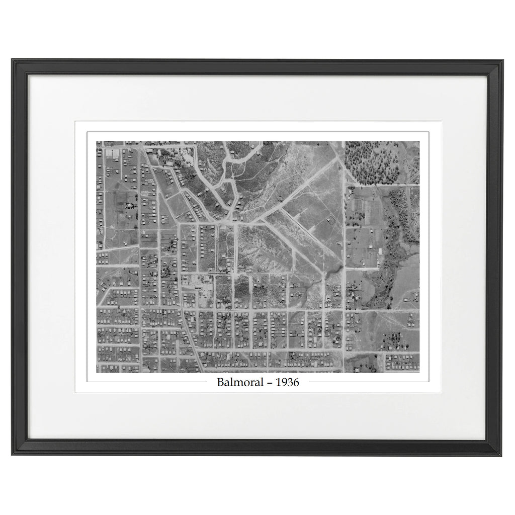
Balmoral
Balmoral
The list of streets covered in the suburb of
Balmoral
can be found
here
.
1936 Balmoral - Aerial Photo - Riding Road
—
Regular price
$129
Suburb Maps
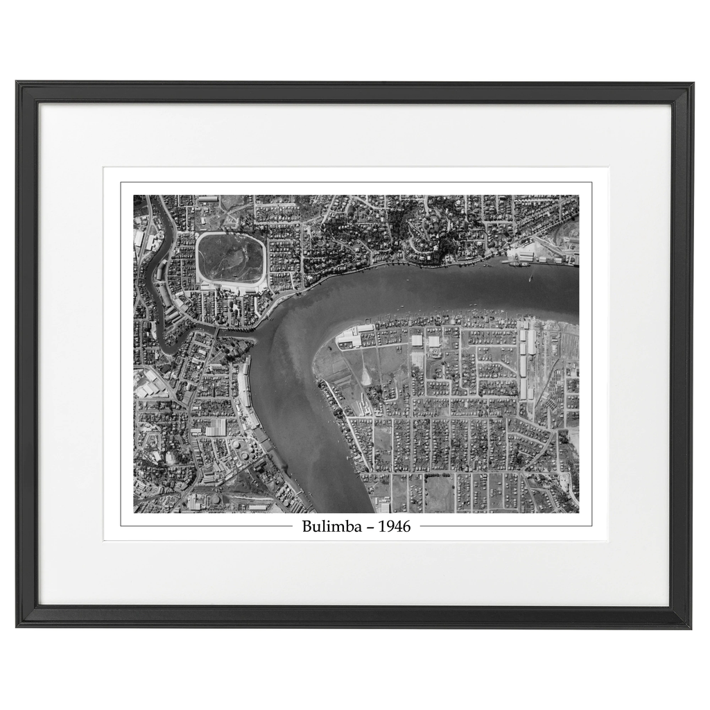
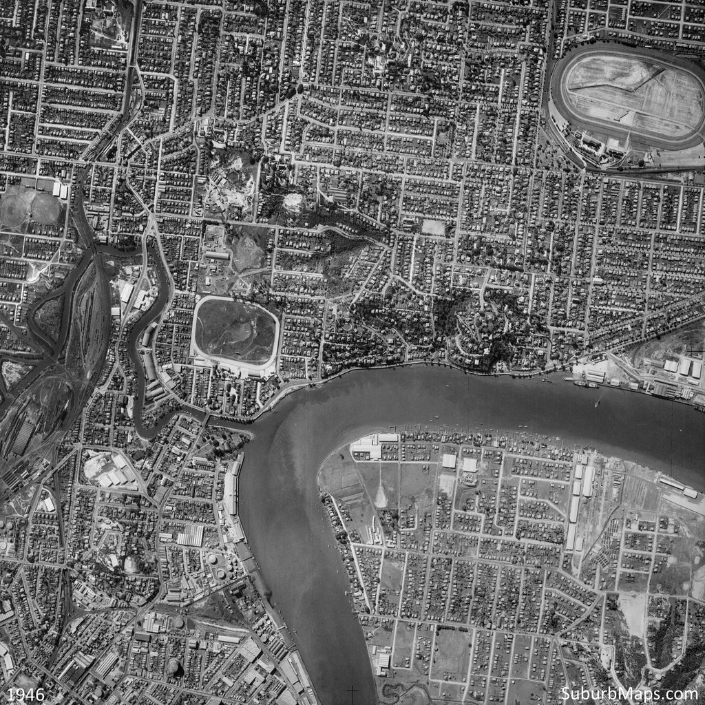
1946 Bulimba - Aerial Photo - Bulimba and Newstead
—
Regular price
$129
Suburb Maps
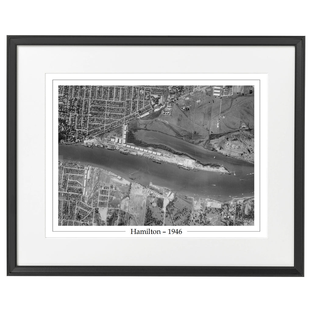
1946 Hamilton - Aerial Photo - Hamilton and Morningside
—
Regular price
$129
Suburb Maps
You might also be interested in the following articles related to Balmoral
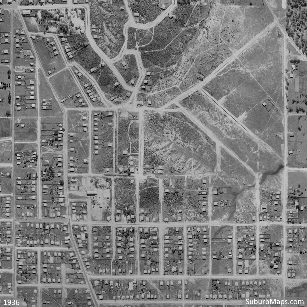
1936 Aerial Photo of Balmoral
1946 Aerial Photo of Bulimba and surrounding areas
Search
Choosing a selection results in a full page refresh.
Press the space key then arrow keys to make a selection.