• Home
  • Buy maps
    • Inner Suburbs
      • Bowen Hills
      • Brisbane
      • East Brisbane
      • Fortitude Valley
      • Herston
      • Highgate Hill
      • Kangaroo Point
      • Kelvin Grove
      • Milton
      • New Farm
      • Newstead
      • Paddington
      • Red Hill
      • Spring Hill
      • Teneriffe
      • West End
      • Woolloongabba
    • Northern Suburbs
      • Albion
      • Alderley
      • Ascot
      • Chermside
      • Chermside West
      • Clayfield
      • Everton Park
      • Gaythorne
      • Gordon Park
      • Grange
      • Hamilton
      • Hendra
      • Kalinga
      • Kedron
      • Keperra
      • Lutwyche
      • Mitchelton
      • Newmarket
      • Northgate
      • Nundah
      • Stafford
      • Stafford Heights
      • Virginia
      • Wavell Heights
      • Wilston
      • Windsor
      • Wooloowin
      • Zillmere
    • Southern Suburbs
      • Annerley
      • Darra
      • Dutton Park
      • Eight Mile Plains
      • Fairfield
      • Greenslopes
      • Holland Park
      • Holland Park West
      • Kuraby
      • Mansfield
      • Moorooka
      • Mt Gravatt East
      • Richlands
      • Rochedale
      • Runcorn
      • Stones Corner
      • Tarragindi
      • Yeerongpilly
      • Yeronga
    • Eastern Suburbs
      • Balmoral
      • Belmont
      • Bulimba
      • Camp Hill
      • Cannon Hill
      • Carina
      • Carina Heights
      • Carindale
      • Chandler
      • Coorparoo
      • Gumdale
      • Hawthorne
      • Manly
      • Morningside
      • Seven Hills
      • Tingalpa
      • Wynnum
      • Wynnum West
    • Western Suburbs
      • Ashgrove
      • Auchenflower
      • Bardon
      • Chelmer
      • Corinda
      • Enoggera
      • Enoggera Reservoir
      • Fig Tree Pocket
      • Graceville
      • Indooroopilly
      • Jindalee
      • Kenmore
      • Mt Ommaney
      • Oxley
      • Sherwood
      • Sinnamon Park
      • St Lucia
      • Taringa
      • Tennyson
      • The Gap
      • Toowong
    • City of Ipswich
      • Basin Pocket
      • Booval
      • East Ipswich
      • Moores Pocket
      • Newtown
      • North Booval
      • North Tivoli
      • Raceview
      • Tivoli
    • Redland City
      • Cleveland
      • Wellington Point
    • Toowoomba Region
    • Aerial Photos
  • Streets
    • Inner Suburbs
      • Bowen Hills
      • Brisbane
      • East Brisbane
      • Fortitude Valley
      • Herston
      • Highgate Hill
      • Kangaroo Point
      • Kelvin Grove
      • Milton
      • New Farm
      • Newstead
      • Paddington
      • Red Hill
      • Spring Hill
      • Teneriffe
      • West End
      • Woolloongabba
    • Northern Suburbs
      • Albion
      • Alderley
      • Chermside
      • Chermside West
      • Clayfield
      • Everton Park
      • Gaythorne
      • Gordon Park
      • Grange
      • Hamilton
      • Hendra
      • Kalinga
      • Kedron
      • Keperra
      • Lutwyche
      • Mitchelton
      • Newmarket
      • Northgate
      • Nundah
      • Stafford
      • Stafford Heights
      • Virginia
      • Wavell Heights
      • Wilston
      • Windsor
      • Wooloowin
      • Zillmere
    • Southern Suburbs
      • Annerley
      • Darra
      • Dutton Park
      • Eight Mile Plains
      • Fairfield
      • Greenslopes
      • Holland Park
      • Holland Park West
      • Kuraby
      • Mansfield
      • Moorooka
      • Mt Gravatt East
      • Richlands
      • Rochedale
      • Runcorn
      • Stones Corner
      • Tarragindi
      • Yeerongpilly
      • Yeronga
    • Eastern Suburbs
      • Balmoral
      • Belmont
      • Bulimba
      • Camp Hill
      • Cannon Hill
      • Carina
      • Carina Heights
      • Carindale
      • Chandler
      • Coorparoo
      • Gumdale
      • Hawthorne
      • Manly
      • Morningside
      • Seven Hills
      • Tingalpa
      • Wynnum
      • Wynnum West
    • Western Suburbs
      • Ashgrove
      • Auchenflower
      • Bardon
      • Chelmer
      • Corinda
      • Enoggera
      • Enoggera Reservoir
      • Fig Tree Pocket
      • Graceville
      • Indooroopilly
      • Jindalee
      • Kenmore
      • Mt Ommaney
      • Oxley
      • Sherwood
      • Sinnamon Park
      • St Lucia
      • Taringa
      • Tennyson
      • The Gap
      • Toowong
    • City of Ipswich
      • Basin Pocket
      • Booval
      • East Ipswich
      • Moores Pocket
      • Newtown
      • North Booval
      • North Tivoli
      • Raceview
      • Tivoli
    • Redland City
      • Cleveland
      • Wellington Point
  • Log In
  • Create Account
  • Search
  • Full List of Suburbs and Maps
  • Buy Maps
  • Buy Aerial Photos
  • Contact Us
  • Frame Sizes
  • Terms of Service
  • Estate Map Timeline
  • Blog - News
  • Blog - Aerial Photos
  • Blog - Historical Images
  • Refund Policy
  • Privacy Policy
  • Shipping Policy
Suburb Maps
  • Home
  • Buy maps
    • Inner Suburbs
      • Bowen Hills
      • Brisbane
      • East Brisbane
      • Fortitude Valley
      • Herston
      • Highgate Hill
      • Kangaroo Point
      • Kelvin Grove
      • Milton
      • New Farm
      • Newstead
      • Paddington
      • Red Hill
      • Spring Hill
      • Teneriffe
      • West End
      • Woolloongabba
    • Northern Suburbs
      • Albion
      • Alderley
      • Ascot
      • Chermside
      • Chermside West
      • Clayfield
      • Everton Park
      • Gaythorne
      • Gordon Park
      • Grange
      • Hamilton
      • Hendra
      • Kalinga
      • Kedron
      • Keperra
      • Lutwyche
      • Mitchelton
      • Newmarket
      • Northgate
      • Nundah
      • Stafford
      • Stafford Heights
      • Virginia
      • Wavell Heights
      • Wilston
      • Windsor
      • Wooloowin
      • Zillmere
    • Southern Suburbs
      • Annerley
      • Darra
      • Dutton Park
      • Eight Mile Plains
      • Fairfield
      • Greenslopes
      • Holland Park
      • Holland Park West
      • Kuraby
      • Mansfield
      • Moorooka
      • Mt Gravatt East
      • Richlands
      • Rochedale
      • Runcorn
      • Stones Corner
      • Tarragindi
      • Yeerongpilly
      • Yeronga
    • Eastern Suburbs
      • Balmoral
      • Belmont
      • Bulimba
      • Camp Hill
      • Cannon Hill
      • Carina
      • Carina Heights
      • Carindale
      • Chandler
      • Coorparoo
      • Gumdale
      • Hawthorne
      • Manly
      • Morningside
      • Seven Hills
      • Tingalpa
      • Wynnum
      • Wynnum West
    • Western Suburbs
      • Ashgrove
      • Auchenflower
      • Bardon
      • Chelmer
      • Corinda
      • Enoggera
      • Enoggera Reservoir
      • Fig Tree Pocket
      • Graceville
      • Indooroopilly
      • Jindalee
      • Kenmore
      • Mt Ommaney
      • Oxley
      • Sherwood
      • Sinnamon Park
      • St Lucia
      • Taringa
      • Tennyson
      • The Gap
      • Toowong
    • City of Ipswich
      • Basin Pocket
      • Booval
      • East Ipswich
      • Moores Pocket
      • Newtown
      • North Booval
      • North Tivoli
      • Raceview
      • Tivoli
    • Redland City
      • Cleveland
      • Wellington Point
    • Toowoomba Region
    • Aerial Photos
  • Streets
    • Inner Suburbs
      • Bowen Hills
      • Brisbane
      • East Brisbane
      • Fortitude Valley
      • Herston
      • Highgate Hill
      • Kangaroo Point
      • Kelvin Grove
      • Milton
      • New Farm
      • Newstead
      • Paddington
      • Red Hill
      • Spring Hill
      • Teneriffe
      • West End
      • Woolloongabba
    • Northern Suburbs
      • Albion
      • Alderley
      • Chermside
      • Chermside West
      • Clayfield
      • Everton Park
      • Gaythorne
      • Gordon Park
      • Grange
      • Hamilton
      • Hendra
      • Kalinga
      • Kedron
      • Keperra
      • Lutwyche
      • Mitchelton
      • Newmarket
      • Northgate
      • Nundah
      • Stafford
      • Stafford Heights
      • Virginia
      • Wavell Heights
      • Wilston
      • Windsor
      • Wooloowin
      • Zillmere
    • Southern Suburbs
      • Annerley
      • Darra
      • Dutton Park
      • Eight Mile Plains
      • Fairfield
      • Greenslopes
      • Holland Park
      • Holland Park West
      • Kuraby
      • Mansfield
      • Moorooka
      • Mt Gravatt East
      • Richlands
      • Rochedale
      • Runcorn
      • Stones Corner
      • Tarragindi
      • Yeerongpilly
      • Yeronga
    • Eastern Suburbs
      • Balmoral
      • Belmont
      • Bulimba
      • Camp Hill
      • Cannon Hill
      • Carina
      • Carina Heights
      • Carindale
      • Chandler
      • Coorparoo
      • Gumdale
      • Hawthorne
      • Manly
      • Morningside
      • Seven Hills
      • Tingalpa
      • Wynnum
      • Wynnum West
    • Western Suburbs
      • Ashgrove
      • Auchenflower
      • Bardon
      • Chelmer
      • Corinda
      • Enoggera
      • Enoggera Reservoir
      • Fig Tree Pocket
      • Graceville
      • Indooroopilly
      • Jindalee
      • Kenmore
      • Mt Ommaney
      • Oxley
      • Sherwood
      • Sinnamon Park
      • St Lucia
      • Taringa
      • Tennyson
      • The Gap
      • Toowong
    • City of Ipswich
      • Basin Pocket
      • Booval
      • East Ipswich
      • Moores Pocket
      • Newtown
      • North Booval
      • North Tivoli
      • Raceview
      • Tivoli
    • Redland City
      • Cleveland
      • Wellington Point
  • Log In
  • Search
  • Cart
Cart
Your cart

  1. Home
  2. News
  3. 1885 West Brisbane Estate - 139 years ago today

1885 West Brisbane Estate - 139 years ago today


October 31, 2024

Today, 139 years ago, on Saturday, 31th October 1885, the West Brisbane Estate in Paddington was being advertised for sale on the ground.

West Brisbane Estate Map

1885 West Brisbane Estate - Paddington, Brisbane

The West Brisbane Estate was advertised in the local papers on the days leading up to the sale. 

Newspaper Advertisement

The West Brisbane Estate covers Given Terrace, Charlotte Street, Plunkett Street (map shows as William Street), Upper Cairns Terrace (map shows as Cairns Terrace), Horsfall Street, Princess Street (map shows as Primrose Street), Alexandra Street (map shows as Jane Street) and Dowse Street.

Google map showing the present day location of West Brisbane Estate

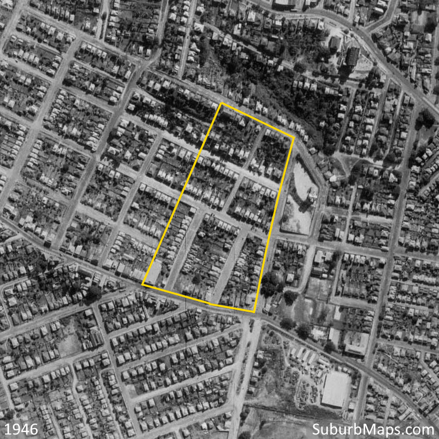
Check out the 1946 Aerial view of the West Brisbane Estate.

1946 Aerial Photo of West Brisbane Estate

1936 Aerial Photo of West Brisbane Estate


More Paddington information available

  • Paddington Estate Maps
  • Paddington Streets
  • Historical Images - Paddington
  • Aerial Photos - Paddington

More Paddington information available

  • Paddington Estate Maps
  • Paddington Streets
  • Historical Images - Paddington
  • Aerial Photos - Paddington
  • News about Paddington
  • Tags: Advertisement Aerial On this Day Paddington
Share Share on Facebook Tweet Tweet on Twitter Pin it Pin on Pinterest

Leave a comment


Please note, comments must be approved before they are published


← Back to News

  • Search
  • Full List of Suburbs and Maps
  • Buy Maps
  • Buy Aerial Photos
  • Contact Us
  • Frame Sizes
  • Terms of Service
  • Estate Map Timeline
  • Blog - News
  • Blog - Aerial Photos
  • Blog - Historical Images
  • Refund Policy
  • Privacy Policy
  • Shipping Policy
  • Facebook
  • Twitter
  • Pinterest
  • Instagram

© 2025, Suburb Maps

Payment methods
  • American Express
  • Apple Pay
  • Google Pay
  • Mastercard
  • PayPal
  • Shop Pay
  • Union Pay
  • Visa
Suburb Maps
$$
Business Address:PO Box 3122,Darra,Queensland,4076,Australia |Email: SuburbMaps@gmail.com.
+61 (0)419 985 572
  • Choosing a selection results in a full page refresh.
  • Press the space key then arrow keys to make a selection.