• Home
  • Buy maps
    • Inner Suburbs
      • Bowen Hills
      • Brisbane
      • East Brisbane
      • Fortitude Valley
      • Herston
      • Highgate Hill
      • Kangaroo Point
      • Kelvin Grove
      • Milton
      • New Farm
      • Newstead
      • Paddington
      • Red Hill
      • Spring Hill
      • Teneriffe
      • West End
      • Woolloongabba
    • Northern Suburbs
      • Albion
      • Alderley
      • Ascot
      • Chermside
      • Chermside West
      • Clayfield
      • Everton Park
      • Gaythorne
      • Gordon Park
      • Grange
      • Hamilton
      • Hendra
      • Kalinga
      • Kedron
      • Keperra
      • Lutwyche
      • Mitchelton
      • Newmarket
      • Northgate
      • Nundah
      • Stafford
      • Stafford Heights
      • Virginia
      • Wavell Heights
      • Wilston
      • Windsor
      • Wooloowin
      • Zillmere
    • Southern Suburbs
      • Annerley
      • Darra
      • Dutton Park
      • Eight Mile Plains
      • Fairfield
      • Greenslopes
      • Holland Park
      • Holland Park West
      • Kuraby
      • Mansfield
      • Moorooka
      • Mt Gravatt East
      • Richlands
      • Rochedale
      • Runcorn
      • Stones Corner
      • Tarragindi
      • Yeerongpilly
      • Yeronga
    • Eastern Suburbs
      • Balmoral
      • Belmont
      • Bulimba
      • Camp Hill
      • Cannon Hill
      • Carina
      • Carina Heights
      • Carindale
      • Chandler
      • Coorparoo
      • Gumdale
      • Hawthorne
      • Manly
      • Morningside
      • Seven Hills
      • Tingalpa
      • Wynnum
      • Wynnum West
    • Western Suburbs
      • Ashgrove
      • Auchenflower
      • Bardon
      • Chelmer
      • Corinda
      • Enoggera
      • Enoggera Reservoir
      • Fig Tree Pocket
      • Graceville
      • Indooroopilly
      • Jindalee
      • Kenmore
      • Mt Ommaney
      • Oxley
      • Sherwood
      • Sinnamon Park
      • St Lucia
      • Taringa
      • Tennyson
      • The Gap
      • Toowong
    • City of Ipswich
      • Basin Pocket
      • Booval
      • East Ipswich
      • Moores Pocket
      • Newtown
      • North Booval
      • North Tivoli
      • Raceview
      • Tivoli
    • Redland City
      • Cleveland
      • Wellington Point
    • Toowoomba Region
    • Aerial Photos
  • Streets
    • Inner Suburbs
      • Bowen Hills
      • Brisbane
      • East Brisbane
      • Fortitude Valley
      • Herston
      • Highgate Hill
      • Kangaroo Point
      • Kelvin Grove
      • Milton
      • New Farm
      • Newstead
      • Paddington
      • Red Hill
      • Spring Hill
      • Teneriffe
      • West End
      • Woolloongabba
    • Northern Suburbs
      • Albion
      • Alderley
      • Chermside
      • Chermside West
      • Clayfield
      • Everton Park
      • Gaythorne
      • Gordon Park
      • Grange
      • Hamilton
      • Hendra
      • Kalinga
      • Kedron
      • Keperra
      • Lutwyche
      • Mitchelton
      • Newmarket
      • Northgate
      • Nundah
      • Stafford
      • Stafford Heights
      • Virginia
      • Wavell Heights
      • Wilston
      • Windsor
      • Wooloowin
      • Zillmere
    • Southern Suburbs
      • Annerley
      • Darra
      • Dutton Park
      • Eight Mile Plains
      • Fairfield
      • Greenslopes
      • Holland Park
      • Holland Park West
      • Kuraby
      • Mansfield
      • Moorooka
      • Mt Gravatt East
      • Richlands
      • Rochedale
      • Runcorn
      • Stones Corner
      • Tarragindi
      • Yeerongpilly
      • Yeronga
    • Eastern Suburbs
      • Balmoral
      • Belmont
      • Bulimba
      • Camp Hill
      • Cannon Hill
      • Carina
      • Carina Heights
      • Carindale
      • Chandler
      • Coorparoo
      • Gumdale
      • Hawthorne
      • Manly
      • Morningside
      • Seven Hills
      • Tingalpa
      • Wynnum
      • Wynnum West
    • Western Suburbs
      • Ashgrove
      • Auchenflower
      • Bardon
      • Chelmer
      • Corinda
      • Enoggera
      • Enoggera Reservoir
      • Fig Tree Pocket
      • Graceville
      • Indooroopilly
      • Jindalee
      • Kenmore
      • Mt Ommaney
      • Oxley
      • Sherwood
      • Sinnamon Park
      • St Lucia
      • Taringa
      • Tennyson
      • The Gap
      • Toowong
    • City of Ipswich
      • Basin Pocket
      • Booval
      • East Ipswich
      • Moores Pocket
      • Newtown
      • North Booval
      • North Tivoli
      • Raceview
      • Tivoli
    • Redland City
      • Cleveland
      • Wellington Point
  • Log In
  • Create Account
  • Search
  • Full List of Suburbs and Maps
  • Buy Maps
  • Buy Aerial Photos
  • Contact Us
  • Frame Sizes
  • Terms of Service
  • Estate Map Timeline
  • Blog - News
  • Blog - Aerial Photos
  • Blog - Historical Images
  • Refund Policy
  • Privacy Policy
  • Shipping Policy
Suburb Maps
  • Home
  • Buy maps
    • Inner Suburbs
      • Bowen Hills
      • Brisbane
      • East Brisbane
      • Fortitude Valley
      • Herston
      • Highgate Hill
      • Kangaroo Point
      • Kelvin Grove
      • Milton
      • New Farm
      • Newstead
      • Paddington
      • Red Hill
      • Spring Hill
      • Teneriffe
      • West End
      • Woolloongabba
    • Northern Suburbs
      • Albion
      • Alderley
      • Ascot
      • Chermside
      • Chermside West
      • Clayfield
      • Everton Park
      • Gaythorne
      • Gordon Park
      • Grange
      • Hamilton
      • Hendra
      • Kalinga
      • Kedron
      • Keperra
      • Lutwyche
      • Mitchelton
      • Newmarket
      • Northgate
      • Nundah
      • Stafford
      • Stafford Heights
      • Virginia
      • Wavell Heights
      • Wilston
      • Windsor
      • Wooloowin
      • Zillmere
    • Southern Suburbs
      • Annerley
      • Darra
      • Dutton Park
      • Eight Mile Plains
      • Fairfield
      • Greenslopes
      • Holland Park
      • Holland Park West
      • Kuraby
      • Mansfield
      • Moorooka
      • Mt Gravatt East
      • Richlands
      • Rochedale
      • Runcorn
      • Stones Corner
      • Tarragindi
      • Yeerongpilly
      • Yeronga
    • Eastern Suburbs
      • Balmoral
      • Belmont
      • Bulimba
      • Camp Hill
      • Cannon Hill
      • Carina
      • Carina Heights
      • Carindale
      • Chandler
      • Coorparoo
      • Gumdale
      • Hawthorne
      • Manly
      • Morningside
      • Seven Hills
      • Tingalpa
      • Wynnum
      • Wynnum West
    • Western Suburbs
      • Ashgrove
      • Auchenflower
      • Bardon
      • Chelmer
      • Corinda
      • Enoggera
      • Enoggera Reservoir
      • Fig Tree Pocket
      • Graceville
      • Indooroopilly
      • Jindalee
      • Kenmore
      • Mt Ommaney
      • Oxley
      • Sherwood
      • Sinnamon Park
      • St Lucia
      • Taringa
      • Tennyson
      • The Gap
      • Toowong
    • City of Ipswich
      • Basin Pocket
      • Booval
      • East Ipswich
      • Moores Pocket
      • Newtown
      • North Booval
      • North Tivoli
      • Raceview
      • Tivoli
    • Redland City
      • Cleveland
      • Wellington Point
    • Toowoomba Region
    • Aerial Photos
  • Streets
    • Inner Suburbs
      • Bowen Hills
      • Brisbane
      • East Brisbane
      • Fortitude Valley
      • Herston
      • Highgate Hill
      • Kangaroo Point
      • Kelvin Grove
      • Milton
      • New Farm
      • Newstead
      • Paddington
      • Red Hill
      • Spring Hill
      • Teneriffe
      • West End
      • Woolloongabba
    • Northern Suburbs
      • Albion
      • Alderley
      • Chermside
      • Chermside West
      • Clayfield
      • Everton Park
      • Gaythorne
      • Gordon Park
      • Grange
      • Hamilton
      • Hendra
      • Kalinga
      • Kedron
      • Keperra
      • Lutwyche
      • Mitchelton
      • Newmarket
      • Northgate
      • Nundah
      • Stafford
      • Stafford Heights
      • Virginia
      • Wavell Heights
      • Wilston
      • Windsor
      • Wooloowin
      • Zillmere
    • Southern Suburbs
      • Annerley
      • Darra
      • Dutton Park
      • Eight Mile Plains
      • Fairfield
      • Greenslopes
      • Holland Park
      • Holland Park West
      • Kuraby
      • Mansfield
      • Moorooka
      • Mt Gravatt East
      • Richlands
      • Rochedale
      • Runcorn
      • Stones Corner
      • Tarragindi
      • Yeerongpilly
      • Yeronga
    • Eastern Suburbs
      • Balmoral
      • Belmont
      • Bulimba
      • Camp Hill
      • Cannon Hill
      • Carina
      • Carina Heights
      • Carindale
      • Chandler
      • Coorparoo
      • Gumdale
      • Hawthorne
      • Manly
      • Morningside
      • Seven Hills
      • Tingalpa
      • Wynnum
      • Wynnum West
    • Western Suburbs
      • Ashgrove
      • Auchenflower
      • Bardon
      • Chelmer
      • Corinda
      • Enoggera
      • Enoggera Reservoir
      • Fig Tree Pocket
      • Graceville
      • Indooroopilly
      • Jindalee
      • Kenmore
      • Mt Ommaney
      • Oxley
      • Sherwood
      • Sinnamon Park
      • St Lucia
      • Taringa
      • Tennyson
      • The Gap
      • Toowong
    • City of Ipswich
      • Basin Pocket
      • Booval
      • East Ipswich
      • Moores Pocket
      • Newtown
      • North Booval
      • North Tivoli
      • Raceview
      • Tivoli
    • Redland City
      • Cleveland
      • Wellington Point
  • Log In
  • Search
  • Cart
Cart
Your cart

  1. Home
  2. 100 year old maps

100 year old maps


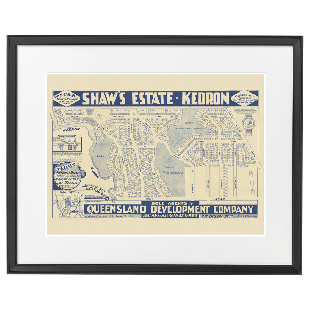
Here are our 100 year old maps from 1925 celebrating 100 years old this year.

1925 Wavell Heights - Shaw's Estate, Kedron
1925 Wavell Heights - Shaw's Estate, Kedron — Regular price $89 +

Suburb Maps


  • Search
  • Full List of Suburbs and Maps
  • Buy Maps
  • Buy Aerial Photos
  • Contact Us
  • Frame Sizes
  • Terms of Service
  • Estate Map Timeline
  • Blog - News
  • Blog - Aerial Photos
  • Blog - Historical Images
  • Refund Policy
  • Privacy Policy
  • Shipping Policy
  • Facebook
  • Twitter
  • Pinterest
  • Instagram

© 2025, Suburb Maps

Payment methods
  • American Express
  • Apple Pay
  • Google Pay
  • Mastercard
  • PayPal
  • Shop Pay
  • Union Pay
  • Visa
Suburb Maps
$$
Business Address:PO Box 3122,Darra,Queensland,4076,Australia |Email: SuburbMaps@gmail.com.
+61 (0)419 985 572
  • Choosing a selection results in a full page refresh.
  • Press the space key then arrow keys to make a selection.