


Suburb Maps
1946 Grange - Aerial Photo - Grange in 1946
Regular price
$129.00
Unit price
per
Free shipping for Brisbane deliveries.
Other Shipping costs calculated at checkout.
Other Shipping costs calculated at checkout.
This Suburb Maps also appears in the following collections:
- All Maps (217 products)
- City of Brisbane (203 products)
- Brisbane - Northern Suburbs (46 products)
- Aerial Photos (38 products)
- Windsor (10 products)
- Wilston (7 products)
- Newmarket (7 products)
- Lutwyche (7 products)
- Gordon Park (7 products)
- Grange (6 products)
- Stafford (3 products)
Historic Aerial Photo of Grange in 1946
1946 Aerial Photo of Grange in Brisbane
See also:
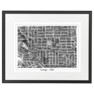

The 1946 Aerial Photo of Grange in 1946 includes 173 streets in Grange, Windsor, Gordon Park, Lutwyche, Wilston, Newmarket and Stafford.
43 streets in Grange:
- Agincourt Street
- Alcester Street
- Baltic Street
- Bega Street
- Blandford Street
- Bruce Street
- Carberry Street
- Carroll Crescent
- Chermside Street
- Cheviot Street
- Colston Road
- Consort Street
- Corner Street
- Daisy Street
- Daphne Street
- Days Road
- Dennis Street
- Eighth Avenue
- Evelyn Street
- Ferres Street
- Frome Street
- Gracemere Street
- Grange Road
- Howard Street
- Inglis Street
- Jean Street
- Lanham Avenue
- Leyton Street
- Mardale Street
- Meecham Street
- Montpelier Street
- Myrtle Street
- Newton Street
- Primrose Street
- Prince Street
- Raymont Road
- Robe Street
- Sellheim Street
- Stevenson Street
- Thomas Street
- Uxbridge Street
- Watson Street
- Wilston Road
41 streets in Windsor:
- Anderson Street
- Antill Street
- Arwin Terrace
- Bank Street
- Bess Street
- Bowser Street
- Brickfield Street
- Brook Street
- Cameron Street
- Constitution Road
- Crowther Street
- Cumberland Street
- Drury Street
- Fairleigh Street
- Fifth Avenue
- Flaherty Street
- Flower Street
- Gilbert Road
- Goodacre Street
- Graham Street
- Harris Lane
- Harris Street
- Hawdon Street
- Hooker Street
- Jessop Street
- Leda Street
- Lutwyche Road
- Mackay Street
- Main Avenue
- Maygar Street
- Mckenzie Street
- Palmer Street
- Parsons Street
- Reid Street
- Roblane Street
- Rougham Street
- Rupert Street
- Silvester Street
- Tenth Avenue
- Thorne Street
- Whish Street
24 streets in Gordon Park:
- Aberdeen Terrace
- Archer Street
- Beaconsfield Terrace
- Bedford Street
- Gordon Street
- Groom Street
- Hamilton Street
- Huntly Street
- Ilford Street
- Johnston Street
- Kate Street
- Khartoum Street
- Little Barron Street
- Mcpherson Street
- Montgomery Street
- Montrose Street
- Piper Street
- Richmond Street
- Roxby Street
- Shamrock Street
- Stirling Street
- Thistle Street
- Tindal Street
- Willis Street
23 streets in Lutwyche:
- Boomerang Street
- Bradshaw Street
- Brickfield Street
- Brook Street
- Chapel Street
- Chelmsford Avenue
- Damon Road
- Ernest Street
- Fuller Street
- Gilbert Road
- Gunyah Street
- Lamington Avenue
- Lucas Street
- Lutwyche Road
- Mcgregor Avenue
- Reid Lane
- Sears Street
- Spear Street
- Swinburne Street
- Thistle Street
- Tobruk Street
- Wesley Street
- Yarraman Street
20 streets in Wilston:
- Angliss Street
- Antill Street
- Dalrymple Street
- Days Road
- Dibley Avenue
- Dover Street
- Eighth Avenue
- Fifth Avenue
- Hawdon Street
- Kedron Brook Road
- Lamont Road
- Lovedale Street
- Main Avenue
- Melvin Street
- Montpelier Street
- Olney Street
- Paling Avenue
- Ray Street
- Stain Street
- Vale Street
12 streets in Newmarket:
- Clegg Parade
- Daisy Street
- Gaunt Street
- Gracemere Street
- Kooemba Street
- Lansdowne Street
- Mina Parade
- Montpelier Street
- Robe Street
- South Street
- Watson Street
- Wilston Road
10 streets in Stafford:
- Babarra Street
- Billabong Street
- Bilston Street
- Gamelin Crescent
- Harvton Street
- Hayward Street
- Stone Street
- Wagsall Street
- Webster Road
- Wolverhampton Street
Year: 1946
Location: Grange, Brisbane, Queensland, Australia
The aerial photo includes the following present day locations:
- Wilston Grange Kindergarten
- C&K Lutwyche-Windsor Kindergarten
- Saint Columba's Primary School
- Wilston State School
- Saint Mary of the Cross School
- Windsor State School
- Archer Street Park
- Gordon Park Scout Group
- Thistle Street Park
- Baxter Park
- Grange Thistle
- Halford Park
- Lanham Park
- Wilston Scouts
- Clark Park
- W. A. Jolly Park
- Wesley Street Park
- Prentice Park
- Newmarket Pools
- Bert Hinkler Park
- Windsor Memorial Park
- Windsor Town Quarry Park
- Saint Carthage's
- Kingdom Hall of Jehovah's Witnesses
- St Albans Anglican Church
- Brisbane Christadelphian
- Lutwyche Mosque
- Salvation Army
- Salvation Army Stafford
- Saint Columba's
- Wilston Uniting Memorial Church
- Marché du Macaron
- Mistress of Spice
- 7-Eleven
- BP Grange
- Cellarbrations
- Chopperworks
- Contrasts Hair Studio
- Crushers Leagues Club
- Crust Gourmet Pizza Bar
- Espresso to Go
- Grange Library
- Grange News
- Hauxham's Pharmacy
- Hermitage Gardens
- Insight Health Care
- Liberty Petrol Station
- Matilda
- Posh Beads
- Puppy Shack
- Shot Espresso
- The Grange Club
- The Ironing Shop
- The Ming Inn
- Toplock
- Urban Cellars
- 7-Eleven
- Asia Massage
- Aussie Home Loans
- Canale Travel
- Crown Hotel
- Ecksrsley's Art and Craft
- Espresso House Windsor
- Harrison Real Estate
- Hong Kong BBQ Restaurant
- Market Central Lutwyche
- Tom Wallace Cycles
- TRICICLO
- The Good Guys Lutyche
- Aqua Gardening Hydroponics & Aquaponics Shop
- Elixir Coffee (Expresso Lounge)
- Q Roasters
- The Soul Pantry
- The Stafford Tavern
- Astute Wilston
- Sichuan Bang Bang - Wilston
- Kitchens by Kathie
- Old Windsor Town Council Chambers